THE NEW YORK STATE DEPARTMENT OF TRANSPORTATION (NYSDOT) IS DESIGNING A NEW EXPRESSWAY TO REPLACE THE CURRENT EXPRESSWAY THAT RUNS THROUGH DELAWARE PARK …
NYSDOT calls the new expressway a boulevard. They claim it will be in harmony with its surroundings. In the past they promised it would be “park Themed.” But, in reality it looks like it will not be much different from the Scajaquada Expressway that is currently in place.
Oh, it will have some new shrubs, some asphalt paths running along side, and some fresh smooth pavement. Don’t be fooled though, it will still be a high-capacity road designed to pass cars through the park at a relatively high-speed. NYSDOT admits as much when they describe the highway as critical transportation link between I-190 and NYS Route 33. High capacity roads should not be in a park. The State should not be planning a new highway in Delaware Park. The only reason it is in the park is that it was the cheapest land they could grab back in the 1950’s.
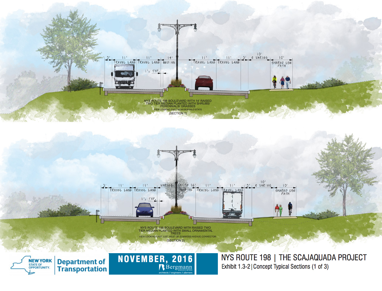
Yes, the engineers have eliminated a few on and off ramps here and there. Plus, it will have a median! Medians are good right? The planned barrier like median, traversing much of the renovated road, will be nothing more that a strip of sadly trapped plants. Don’t worry though it has a purpose. The median will stop those pesky park users from crossing the street where they want, and bonus, it will help drivers feel confident when traveling at higher speeds. The planned sparse scattering of cross walks should satisfy the bikers and park users right?
Speaking of cross walks. There is one estimated to be about 100 feet long at the Parkside intersection! The Parkside intersection is an engineering glory to behold. It is a gigantic paved expanse reminiscent of Red Square. It has up to eight lanes in some places. A pedestrian with any kind of mobility issues will have a hard time getting across this road. On the bright side, it looks like the pavement will have color or something.


The typical design cross sections along with various renderings taken from the Draft Environmental Impact Study (DEIS) indicate that there is not going to be much effort on the part of NYSDOT to create an urban parkway like experience. The design drawings indicate that it will pretty much be a high-capacity road which is decorated with scatter shot trees and shrubs, which mostly serve to fill up the blank spaces in the plans and renderings. Notice, in the rendering above, how the cars politely stop at the cross walks to let people cross. Don’t be too sad though. It looks like they will be using pretend historic highway light poles, which tower 30 to 40 feet above the road.
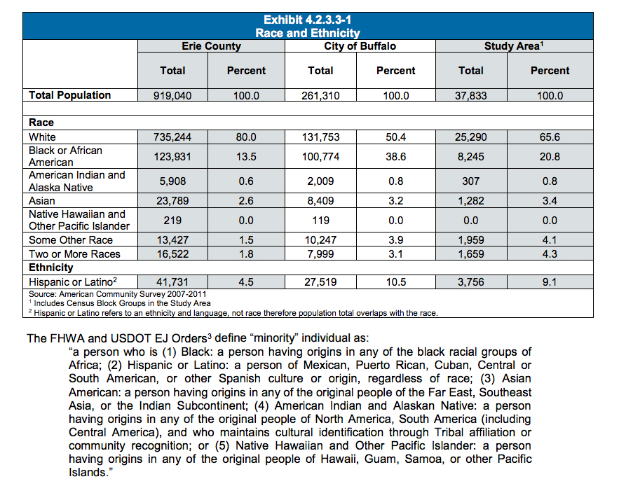
Speaking of the DEIS, it is composed of 12 volumes, each with hundreds of pages. The volumes are packed with charts, endless paragraphs of gibberish, meeting minutes, plans, and maps, Much of this mass of information adds nothing of substance to why a high-capacity road needs to be in Delaware Park. The example spread sheet below shows us that there are no Native Hawaiians or Pacific Islanders living in the study area. This is the silliness we go through today to design cities. If you want to waste a few months of your life reading this nonsense you can find the reports on the NYSDOT project web site.

If you think there is plenty of time to stop this disaster from becoming real you would be wrong. The state has an aggressive schedule planned, which has the project starting next Fall and finishing up in Fall of. Time is quickly running out to make your voice heard. In addition to attending the Wednesday meeting can get involved with the following groups, which are working diligently to shape a better Delaware Park without a highway cutting it in half.
Scajaquada Corridor Coalition – As the name suggests, a coalition of groups fighting for sanity. Here is a bit from them:
Based on our initial review, the Scajaquada Corridor Coalition (SCC), which represents multiple stakeholders, including the Olmsted Parks Conservancy, the Parkside Community Association, and GObike Buffalo, as well as community groups and thousands of individuals, opposes the current project design because it fails to meet the aspirational vision laid out by Governor Cuomo and supported by the community since this process began in 2001.
The SCC vehemently opposes the current boulevard design due to:
- The lack of a meaningful and engaging public input process while NYSDOT ignores multiple submissions by community organizations with constructive recommendations;
- Prioritization of vehicle traffic over the safety of vulnerable users through:
- Over-sized intersections that will make crossings unsafe for pedestrians and bicyclists;
- Medians throughout the corridor at the expense of park space and on-street bicycle facilities; and
- Adverse impacts upon the Historic Olmsted Park and Parkway System as well as the surrounding cultural and educational institutions and business districts; and
- The plan’s limited scope, including the absence of addressing impacted communities west of Grant Street and east of Parkside Avenue.
As the New Buffalo continues to re-invent itself becoming a great city once again, NYSDOT is stuck in the Robert Moses-era of planning mistakes by focusing singularly on moving vehicles through our community. At no additional cost, the community’s Scajaquada Boulevard vision could cement our city’s renaissance if vehicle traffic is not the sole consideration of its design; instead, people are.
The Black Rock Riverside Alliance (BRRA), another coalition of residents, advocating for Buffalo’s historic waterfront neighborhoods, put together their own vision of what the Scajaquada Corridor could and should be. in place of the highway hey show a regular city street winding along a restored creek. They give Buffalo State College a waterfront edge and link the campus to surrounding neighborhoods. At the Niagara River they eliminate the hideous tangle of highway ramps in favor of a water edge park. It is the kind of far-sighted thinking completely absent from the 1000’s of pages in the NYSDOT Scajaquada study.
Buffalo Olmsted Parks Conservancy is well-known for their efforts to restore and advocate for the parks. Eliminating the highway through Delaware Park would be a major step in bringing back one of Buffalo’s greatest gifts from the past:
It is the position of the BOPC that the high-speed vehicle traffic cutting through Delaware Park on Route 198 is an intrusion into the landscape and compromises the historic integrity of Frederick Law Olmsted’s design for the Park. Olmsted intended the park experience to be that of immersion into the natural environment leaving behind all the distractions and stress of urban life, not to be subjected to the sights and sounds of expressway traffic. The construction of Route 198 through the park in the late 1950s destroyed that pastoral and picturesque experience in a way that cannot be mitigated through barriers, walls or shrubbery.
It is the BOPC’s stated position that the former expressway should never have been imposed on Delaware Park, and it should be removed. BOPC believes the design philosophy for a new boulevard first and foremost should be in harmony with the surrounding historic landscape. Within Delaware Park, “harmony” is to be defined as the least possible intrusion for the park user experience.
- Constructing any roadway through the Park in a manner faithful to Olmsted design.
- Restoring unimpeded access from the Meadow to Hoyt Lake, relocate vehicular traffic and provide restoration of the Delaware Avenue Bridge to park activities and the uses for which it was designed.
- Improving park access for multi-modal use from surrounding neighborhoods and provides connectivity between landscape features of Delaware Park, through improved at-grade intersections at Agassiz Circle, Delaware Ave, Lincoln Pkwy., Elmwood Ave and Grant St and improved grade-separated routes between intersections.
- Providing traffic-calming measures along the entire corridor with a 30 mph or less roadway design, including the use of gateway features and diverting commercial traffic from the Park.
- Removing median features for the roadway corridor between intersections in order to narrow the overall roadway intrusion to the greatest extent possible, and to maximize valuable historic landscape restoration and increase natural landscape buffers.
- Recessing or lowering elevations of the roadway corridor through the Park to the greatest extent possible and minimizing the visual and auditory intrusion to the park user experience.
This is what NYSDOT thinks is appropriate for Delaware park. It is not. Go to the public meeting, call the mayor, call your councilman, call your state representatives. Make sure they know in no uncertain terms that the people of Buffalo want their park back now.

Written by David Steele
Source: https://www.buffalorising.com/2016/12/expressway-planned-for-delaware-park/#disqus_thread


